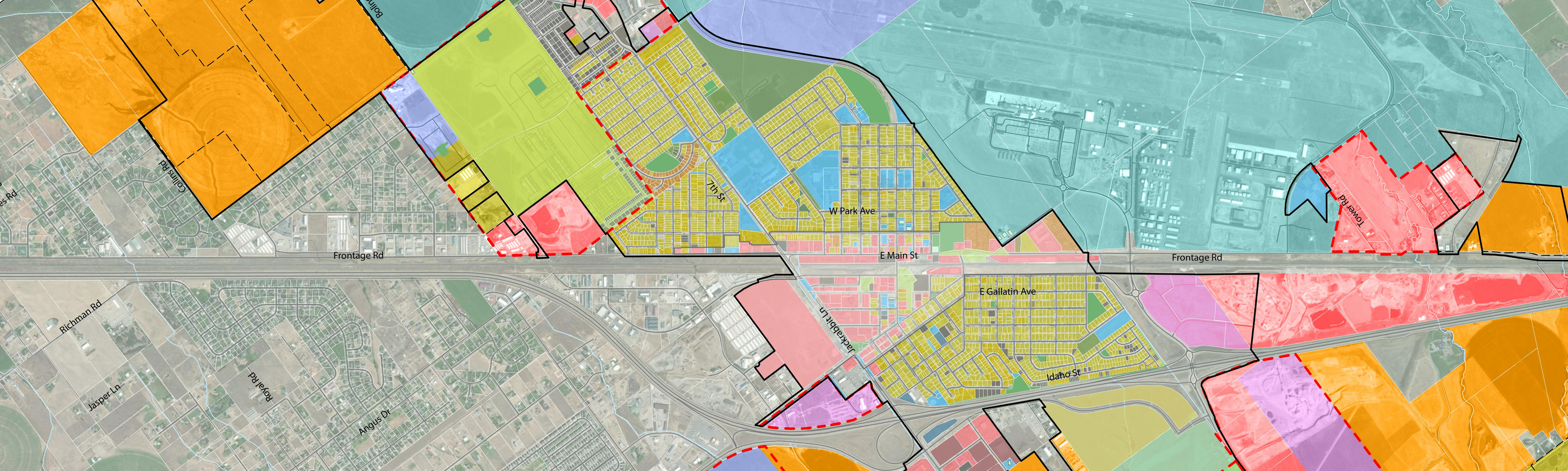
Future Land Use Map
The City of Belgrade updated its Future Land Use Map (FLUM) in 2020 as part of a Growth Policy Update. Since then, there have been significant changes in land use, rapid population growth, and regulatory changes like an update to the City's Zoning Code that have prompted City staff to revisit the FLUM. There were also sections within the Belgrade Planning Area that were left undesignated on the map, which leaves them subject to change/development unless an amendment to the map is made. It's time for an update to the Future Land Use Map to ensure that growth reflects the vision of the Belgrade community.
So, what is a Future Land Use Map?
The Future Land Use Map delineates appropriate locations for future uses, establishes the community’s vision for the placement of housing, employment, social activities, and protection of natural areas. Future Land Use 'Designations' provide guidance for new development and redevelopment, describing the typical mix of land uses and design characteristics that are desirable to create distinct areas of the city. The map does not establish zoning district boundaries or regulations, nor guarantee that individual properties are suitable for the full range of design characteristics described within each category. Land use decisions on individual properties should consider not only the Future Land Use Map, but also other Growth Policy policies, the context of the surrounding area, and other individual site considerations that cannot be evaluated as part of the high-level policy guidance of the Growth Policy.

What is the Belgrade Planning Area?
Equally as important as planning for the future inside the City of Belgrade is planning for its surrounding area. The Belgrade Planning Area is a 4.5 mile "donut" surrounding the City of Belgrade's municipal boundaries. Although the Planning Area was established in 1975, it has not always been planned for in Growth Policies. Taking steps to ensure that development of this area aligns with Belgrade's vision is important for the future of the community.
State law recognizes that good planning doesn’t always follow municipal boundaries and allows the authority of a city-county planning board to extend into areas both inside an incorporated city boundary and in “contiguous unincorporated area outside the city”. As development continues to occur inside the City of Belgrade, the impacts and pressures can extend outside city limits into the adjacent planning area.
The intent of the Future Land Use Map for the Belgrade Planning Area is to provide Gallatin County and the City of Belgrade an opportunity to look at how development is taking place in this area, identify what is working and what is not, and to work together to create a vision for the future that works to ease any adverse impacts and pressures. The FLUM can also create a framework to help the city and county adequately plan for the provision of services and infrastructure for the future.

How can I get involved?
Community input is critical to establishing the vision for Belgrade's future. You can get involved by:
 Sharing your ideas below!
![]() Coming to an Open House!
Coming to an Open House!
 [coming soon] Tagging the interactive map!
-
Share Share your Ideas! on Facebook Share Share your Ideas! on Twitter Share Share your Ideas! on Linkedin Email Share your Ideas! linkView All Ideas
Do you have any big ideas for future land use in Belgrade and its Planning Area? Share your thoughts by posting an idea, or liking someone else's idea! You can even upload images of land uses you like in Belgrade or in other communities that you'd like to see.

